Brief Chronology Of How Mazaua
(Magellan’s Port) Became Limasawa (Isle Without Anchorage)
1521 – Magellan fleet anchors west of
skerry named Mazaua. Five seamen write eyewitness accounts
on Mazaua where mass was held and
cross planted.
1536 – G.B. Ramusio restranslates back
to Italian from French translation of
firsthand account of
Antonio
Pigafetta. Mazaua becomes Butuan, Stop-over isle on way to Cebu
becomes
“Messana” is Gatighan in Pigafetta map.
1601 – Antonio de Herrera relates Mazaua
incident faithful to the actual incident.
1663 – Fr. F. Colín recounts incident as
Ramusio wrote it, renames stop-over isle
Dimasaua to
signify it was not the site of the first mass, di is Bisayan of “not”
1667 – Fr. F. Combés recounts incident
of Ramusio, renames stop-over isle Limasaua
1734 – Fr. Pedro Murillo Velarde draws
map tracing Magellan route incldg. Butuan incident and
stop-over
in Limasaua. His book Geographica gives other name for isle Dimasaua.
1734 – French cartographer Jacques N.
Bellin publishes his pliagiaristic copy of Murillo map.
1794 – Carlo Amoretti discovers one of 4
extant Pigafetta codices, this Italian is now known
as Ambrosian
codex, the more known of all.
1800 – Amoretti publishes transcription
of codex. He says in a footnote Mazaua may be Bellin’s
Limasava,
fusing the anchorage (Mazaua) and the stopover isle (Gatighan). A second
footnote states Mazaua’s latitude 90 40’ N is the identical as
Limasava’s (90 56’ N).
1825 – Francisco Albo eyewitness account
(Madrid copy) published in Navarette’s Colección…
Albo’s latitude for Mazaua in this
copy is 90 40’ N same as Pigafetta’s.
1826 – Genoese Pilot’s firsthand
account, Lisbon copy, published by Academia Real das Scinceas de
Lisboa. Latitude of isle is 90
N but its name is transcribed as Macangor.
1874 – Lord Stanley of Alderley’s
English translations of Pigafetta, Albo and Genoese Pilot
published. Stanley repeats
Amoretti’s note that Mazaua and Limasaua maybe one and the
same.
Albo’s latitude, based on London copy, is 90 20’ N. Genoese Pilot’s
name for skerry, in
Paris
manuscript, is Maçaguoa, according to Stanley.
1894 – Andrea da Mosto’s transcription
of Ambrosian comes out. It establishes the text of the codex
on which J. A. Robertson’s based his
English translation that Filipino historians invoke.
1895 – Dr. T.H. Pardo de Tavera, after
reading Spanish translation of Amoretti’s text, declares
Butuan is not site of first mass but
fails to acknowledge Amoretti.
1902 – J.A. Robertson, in Vol. II of
Philippine Islands…cites Stanley’s footnote but fails to state
Stanley is just citing Amoretti
publishes English tr. of Ambrosian.
1903 - Fr.
Pablo Pastells, in annotation of Colín’s Labor…, restates Tavera’s declaration
without
adverting
to Tavera and without acknowledging Amoretti.
1906 - Robertson’s
English tr. of Mosto’s transcription published. In a footnote he states as
certain,
without proof or reasoned argument,
that Mazaua is “doubtless” Limasawa. He still fails to
acknowledge Amoretti’s paternity of
the Limasawa hypothesis.
1911 – J. Denucé’s Magellan La
question…states Albo’s Mazaua latitude in London copy is 90 20’
N
which
he repeats in his transcription of Pigafetta’s MS fr. 5650.
1920 – Ginés de Mafra account published
in Madrid. Mafra is unknown to Philippine historians save
Wm.
H. Scott. This Magellan seaman returned to Mazaua in 1543. He states Mazaua’s
circumference is 3 to 4 leguas and
that it is 15 leguas below 1521 Butuan.
1960 – Congress passes law, R.A. 2733,
naming Limasawa site of first mass. Not one of the legislators
had
read Pigafetta’s 4 MSS, Albo, Genoese Pilot, Ginés de Mafra, and Martin de
Ayamonte.
1998 - National
Historical Institute dismisses Mafra as fake, ignores other evidences that show
Limasawa does not possess a single
property of Mazaua. It declares Mazaua and Limasawa
as
identical—the two are perfect, exact, total equal of each other.
2001 - Dr.
Ricarte S. Javelosa, geomorphologist, and team discovers hidden isle now fused
with
present-day Butuan which has some of
the earmarks of Mazaua.
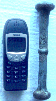
2001 - Archaeologist M.J.L. Bolunia
unearths metal pestle. If brass, the artifact could be
proof Mazaua
is buried in Butuan since Magellan carried one and only one
brass pestle.
Philippine Nuclear Research Institute establishes it is bronze.
2001 - Talks
with National Geographic Society to fund further Mazaua geo-archaeological
investigation
enters formal proposal stage. Early
talks also start for help of Philippine
Nuclear
Research Institute and possible assistance of International Atomic Energy Agency
of
Vienna.
Study of Pinamanculan and Latest Finding on
Mazaua (Magellan’s Port)
Two incidents and a new historiographical insight mark the continuing
search
for Magellan's lost port, Mazaua.
On November 29, 2001 geomorphologist Dr. Ricarte S. Javelosa and
geologist
Fred Carpio made probings in the Chinese cemetery in Bancasi (the side
going
towards Mt. Mayapay) in Butuan City and discovered the soil there is
limestone. That alone establishes the Pinamanculan "isle" that he
earlier
hypothesized to be definitely an isle. That same week, Ms. Mary Jane
Louise
Bolunia (who dug up a bronze pestle of indeterminate provenance in May
30,
2001) dug up pre-Hispanic bones also in Pinamanculan, further
strengthening
the finding of Javelosa earlier that Pinamanculan is one of the oldest
geological structures in Butuan.
The limestone discovery has prompted Dr. Javelosa to rethink many of
the
things he had assumed which now turns out incorrect. Geologically
speaking,
according to Dr. Javelosa, even today Pinamanculan is "detached" from
mainland Butuan because of creeks and other waterways that completely
surround it. The coconut grooves that he earlier thought indicated
solid
ground now turns out to be alluvial sedimentations. He hypothesizes
that the
shoreline of Butuan was way further inland of present-day Butuan. He is
convinced Pinamanculan was under sea water or at least parts were
brackish
water.
All that Dr. Javelosa's new findings tell us is that Pinamanculan was
indeed
an isle. It does not in any way tell us it is Mazaua. Only authentic
remains
of the 1521 Magellan visit and the 1543 Mafra second visit will prove
that.
In other words, archaeological diggings will be the next major step
that
alone will prove if Pinamanculan was Mazaua.
The bronze pestle Bolunia discovered is at least tantalizing. We know
it is
not the item brought by the Magellan expedition. The fleet had one and
only
one pestle and it was brass. The pestle is approximately 18 cm or just
a
little over 7 inches. Its specific gravity is 7.37 g/ml. Its weight is
408.51 grams (using analytical balance). Was it Mafra's? How old was
it? Who
made it? Was it European? If European, what, Belgian, Portuguese,
Spanish?
If not, what, Chinese? A well-funded study would have tried to
determine the
age of the artifact by analyzing associated materials that can be
carbon-dated. There are suggestions the artifact is 15th or 16th or
17th
century material because of the Ming shards/sherds just a few
centimeters
above it.
It is ironic that no one asks if an authentic remains of the Magellan
and
Mafra expedition has been found in Limasawa.
Now as for the historiographical insight. How did we come to the notion
Mazaua is in today's Butuan? Here is how we arrived at that conclusion.
Mafra said that Mazaua was south of 1521 (please remember that he is
talking
of what he knew then at that time) Butuan 15 leguas away. There are at
least
28 values to the legua. How do we know which of the 28 Mafra used. We
know
he is Spanish, so very likely he used the Spanish legua which is 3
nautical
miles to one. We will find confirmation of what he used only after we
are
able to know for sure where Butuan was and where was Mazaua was.
So where was Butuan of 1521? We shall be able to locate 1521 Butuan by
the
latitude of Mazaua. Pigafetta says Mazaua was in 9 degrees 40 minutes
North.
We know this is a wrong latitude because no isle exists in that
latitude. If
Butuan was 45 nautical miles above Mazaua, that puts Butuan at 10
degrees
and 25 minutes N. That latitude is above Mindanao and puts Butuan in
the
Visayas. This at once eliminates Pigafetta's latitude.
The second latitude is that of Albo's, 9 degrees 20 minutes N (which no
Philippine historiographer who has participated in the Mazaua debate
has
discovered: it is in Lord Stanley of Alderley and Jean Denuce). Thus
Butuan
will be in 10 degrees and 5 minutes N. Again this is above Mindanao and
well
into the Visayas. Here we see also the argument or proof that Albo's
latitude for Mazaua is erroneous.
Now, we come to the Genoese Pilot's 9 degrees sharp. Forty-five
nautical
miles from 9 degrees is at latitude 9 degrees and forty-five minutes N.
This
is at the tip of today's Surigao. More precisely, at Bilaa Pt. Here we
see
the coincidence between Mafra's 1521 Butuan and the Genoese Pilot's
latitude
for Mazaua.
What are the other corroborative evidence? The French pilot, Pierres
Plin or
Plun, of the Legaspi expedition said that the gap between Panaon and
1565
Butuan was 4 leguas (12 n.m.). Now the gap between Panaon and today's
Surigao is 11 n.m. Plin's 1565 Butuan cannot be 2001 Butuan which is
more
than 45 n.m. away from Panaon.
A Spanish friar by the name of Sanchez wrote in a letter to the Jesuit
HQ
that fronting 16th century Butuan was Leyte. Today's Butuan can't
possibly
be said to be in front of Leyte. Surigao is fronted by Panaon which is
the
southernmost tip of Leyte.
In another posting, I will describe how an isle that was named
precisely to
signify that NO MASS WAS HELD THERE is today heralded as the site of
the
first mass in the Philippines. As I have been signalling to all
non-navigation historians (all those who have participated in the
Mazaua
debate are neither Magellan scholars nor navigation historians)
Limasawa can
never be Mazaua because it has no anchorage. Mazaua was first and
foremost a
port!
Vicente C. de Jesus